Introduction
Aviation Archaeology is the practice of searching and recovering sites and wreckages of cashed aircraft. The subject is also known as aircraft archaeology, wreckology, and aerospace archaeology, crash hunting and other names. The activities involved include carrying out research using crash reports, finding and documenting the crash, recovering items from wreckages, preserving the artefacts and publishing reports about the crash. Unlike hunting for sunken shipwrecks, this activity is not done in the hopes of recovering sunken treasure as aircraft normally do not carry huge amounts of treasure, and any currency or other valuable artefacts would be destroyed in the crash or in the fire resulting from the crash. The activity has more to do with forensic and mystery seeking requirements, and it helps many times in understanding the reason for the crash. The purpose of this paper is to determine the impacts of aviation “treasure hunters” on American aviation archaeology and historical preservation. This paper also discusses Aviation Archaeology and explores the tasks and equipment required to undertake the activity.
Brief History of Aviation Archaeology
The activity began after World War II when a number of aircraft were shot down in the war and when after the war, flying activity increased and resulted in a number of crashes. In Great Britain in the 1950s, people would come across wreckages of aeroplanes in fields, mountains and many other areas. People would casually gather the wreckage, collect remains of the victims and then bury them. There was no attempt to find out who the victims were or send mementoes and other artefacts to the surviving members of the family. Some avid aircraft enthusiasts then attempted to document the wreckage, photograph the site and then attempt to find out who the crash victims were, where the plane came from, the reason for the crash and so on. Certain guidelines were framed, and this activity acquired methodology and guidelines were created to preserve the remains and properly document details of the crash. After commercial flights became popular, more and more passengers started flying in passenger aircraft, aircraft crashes started increasing. Remains of victims had to be found to clear the insurance formalities. Thus, aviation archaeology assumed greater significance and importance and saw new technology such as metal detectors, GIS, GPS, Sonar, and other devices and applications to be used (Brotherton, 2005).
Objectives and Purpose
Aviation Archaeology has greater importance with more and more people hunting out specific crash sites or hunting for specific planes that have crashed. Modern day airports and flights have extensive information about the passengers in an aircraft. It is possible to instantly know the details of people on board a crashed flight. Since modern day flying requires that pilots file a flight plan that gives coordinates of the route that they would follow, it becomes relatively easy to find the remains of a crashed plane since modern aircraft have GPS transmitters that relay the position of the crash.
The case was different for crashes that occurred 40 to 50 years back when aircraft flew by radio contact or radar. It was not possible to trace the exact location of an aircraft. This is particularly true for the World War II aircraft that included fighter aircraft and bombers taking off quickly and often with just verbal and handwritten notes on who was on the flight. In such cases, tracing the history of the flight, properly identifying a crash and giving proper burial to the victims assumes great importance.
Therefore, a number of amateur enthusiasts have taken up hunting for aircraft wrecks. While these activities are ardent in zeal and enthusiasm, they do not have any proper training or guidance on finding and documenting crash sites. This is very important when establishing details of the wrecks. Moreover, many of the crashes occur in the wilderness, in mountains, forests and deserts and other inaccessible places. It takes a lot of physical effort to reach the wreckage sites and carry out the studies.
This paper would attempt to create the essential framework that would help aviation archaeologists to pick up the skills needed for the proper study of aviation archaeology.
Rationale for the research
Platt (2000) that Aviation archaeologists have been hunting around the UK for the wreckage of about 20000 aeroplanes that were downed in World War II. The author reports that after the movie ‘The Battle of Britain’ was released in 1969, the new generation of people who had only read or heard stories about the war became interested in finding the crash remains of countless aircraft. By the 1970s, thousands of crash sites were discovered and excavated by these amateur archaeologists. It is estimated that more than 5000 wrecks are hidden in the Essex region. The author suggests that there may be hundreds of undiscovered wrecks in the high and remote regions of Scotland and Wales and that with the increased use of technology, it would be possible to find more of the crash sites and wrecks. While some people see it as a hobby, others regard it as a profession and a career. It is estimated that the total value of the wrecks of the UK could be worth a few billion pounds. There is a growing demand for restored World War II aircraft. There is a very big market for military aircraft. A Spitfire fighter plane that could actually fly and be airworthy could fetch as much as half a million pounds, while a US aircraft such as the P-38 Mustang would be worth more than 1 million pounds. While none of the crashed aircraft would be expected to fly, the spare parts and sections of the aircraft that are not damaged and that can be used to restore available aircraft make the wrecks valuable. Aircraft companies that manufactured the vintage aircraft have been closed a long time back. Whatever spares remained have been consumed. It is only the cannibalisation of grounded aircraft that can give spares such as engine parts, propeller shafts, tail fins and tail sections, control panel parts, brake drums and so on. These parts can be harvested, cleaned and repaired and used as spares for existing aircraft. It must be understood that aircraft in those days were not very fast or had excessive high-octane fuel, and they did not fly at great heights as the current aircraft do. Consequently, there is a good chance that aircraft wrecks of the bygone years would be better preserved. So there is a commercial aspect behind hunting for wrecks.
Governments of different countries have diverging views and laws about military wrecks and aircraft belonging to private parties. As per law, the ‘finders keeper’s law of sunken ships in high seas does not hold true for aviation wrecks, and the archaeologists have to report the findings to the appropriate authorities. Therefore, a proper understanding of various laws and rules governing the sites and wreckage has to be made clear and understood.
A very important aspect is proper documentation and examination of the wrecks. These sites require a certain amount of forensic abilities. In some cases, the remains of the crash victims have to be collected properly and subjected to DNA examination so that the next of kin can take proper care of the remains and artefacts. A hasty examination of the remains by just pulling things apart can result in irreparable damage to the evidence. Therefore, archaeologists need to understand the method to be used for analysis and findings of the aircraft, understand how aircraft are to be identified, know how to understand and read crash reports and take up other investigative work.
Another aspect is to find the actual site of wrecks. While aircraft wrecks in and near cities and villages, near human habitation have almost all been unearthed, many of the wrecks that lie in remote mountains, jungles, desert, swamps and even underwater need the use of special equipment, such as GIS, GPS, metal detectors, sonar and other devices. Archaeologists also need to understand how to read maps and travel to remote areas and the survival kit is important.
All these above factors and issues provide the rationale for the thesis. The paper would be covering the above issues and factors. It would provide a single condensed source of information for aviation archaeologists and researchers who would be interested in the subject.
Research Question
The following research questions have been framed:
- Impact of the activity of aviation archaeologists on aviation archaeology.
- Understanding the requirements for aviation archaeologists in the form of crash reports, field equipment and techniques for taking up the activity.
Methodology Used
The student first began by studying a number of publications such as trade magazines, news reports, books and peer-reviewed journals to understand the extent of the subject. After a thorough review of the domain, a number of keywords related to aviation archaeology were noted down. These keywords were again searched to understand their overall impact on the subject and its practices. A long list was prepared to create a list of keywords that would be used in the research. The list was again refined to form a shortlist of final words and headings that were representative of common aviation archaeology principles and practices.
Using these keywords, databases such as ProQuest, Questia, Internet, local university libraries and other sources were searched to find documents that would be considered for the study. The documents were perused to obtain a final set of headings. Then a method was used to extract the required ideas from the documents and rewrite the ideas and content to form different chapters. In the course of writing, important notes and points of an article were noted. These would be later used in the conclusions chapter.
Limitations of the Research
The paper has relied on published reports by eminent researchers in this domain, and the paper lacks details and activities of field visits undertaken by the student.
How the paper is organised
The paper is organised into different chapters, and each chapter has a number of sections. The arrangement is:
“Examination of Crash Reports and Crash Landing Sites”: The chapter discusses the importance of crash reports and where to obtain them. A sample crash report has been analysed in detail. Different sections of the crash report have been examined in detail. The rules and regulations about crash sites and wrecks for the UK and the US have been discussed. The question of the impact of untrained aviation archaeologists has also been examined.
“Technology and equipment needed”: The chapter has discussed in detail the practical aspects of aviation archaeology. The skill of reading maps and learning about navigation have been presented. Different devices such as compass, field-expedient techniques and navigation with GPS have been examined.
Examination of Crash Reports and Crash Landing Sites
Daly (April 1986) has written about the increased number of crashes that have been reported from the drained bogs of Denmark. According to the author, aircraft wrecks have in the UK have been found a long time back. Some may be found in the mountains of Scotland. However, the author suggests that Denmark lay on the route of planes that flew from the UK to Germany and the other way, planes flying from Germany to the UK saw a lot of action. The author points out that over 7000 aeroplanes were lost in the region. Many of them landed in the marshes and bogs of Denmark. This area had been covered by seawater for many centuries. Many of the crashed planes landed in these marshes. It was only in the past couple of decades, when the bogs were being drained, that a number of aircraft of nations such as the UK, the USA and even Germany have been unearthed. The author points out that the soil in this region was waterlogged, soft and salty, and hence the downed aircraft have survived with lesser damages than they would have if they had crashed on land. Recently, a team of boy scouts came across a wreck, complete with a turret machine gun and 700 rounds of heavy calibre, armour-piercing ammunition. The boy scouts managed to extricate the machine gun and even restored it since it had sustained very little damage and it was almost intact. The authorities came to know about this event just in time and managed to confiscate the gun before any serious harm could happen.
Daly reports that there have been many accounts of full and intact B20 bombers being found, and these finds are very hazardous since it is possible that many of the aircraft would have 1000 pound bombs with them or scattered in the nearby region when the aircraft crashed. Many of these bombs are alive and have a fuse that ignites within 1/40th of a second after impact with the ground. Therefore, handling and defusing such unexploded bombs becomes a very difficult task. Often experts from bomb-defusing squads have to be called. The same goes for unexploded munitions, rounds of bullets, shells and other types of ammunition, including handguns and other firearms. It is very dangerous for novices to attempt to pick up or handle such munitions as the decades of exposure to salt, water, and the sun would have weathered away all the safety mechanisms, and mishandling can result in death or severe injury. This is an important aspect that aviation archaeologists have to understand. While they may get involved in tracing a wreck, they should not attempt to salvage through the remains.
The author points out that many of these aircraft attempted to maintain radio silence when flying. The records of their taking off from their respective airbases are never clear. While the British had some order in maintaining the records, the US and Germans did not keep proper records. This is a big problem in identifying the crash and the remains of the airmen who perished in the crash. The aircraft registration number becomes the sole identifying feature of the aircraft along with the aircraft make and the nationality. However, it may be possible that the identification number would have been destroyed in the crash, and in such cases, the coordinates of the crash are noted down, information relayed to the air force or military base, and the personnel then attempt to trace their records and find out who the victims were. When the identification of the aircraft is positive, then the aircraft authorities would attempt to trace out any relatives and surviving members and then give them the information. The author reports that the wartime records just mention a missing aircraft as missing in action over an area and presumed dead. When a wreck is unearthed, and the remains are positively identified, then the surviving members of the victim’s family receive the news with grief and gratitude. While the presumed demise of the airmen is almost a certainty, the survivors often break down and cry when given official confirmation. Still, according to the author, no one ever has become angry at being given the news, and the news is greeted with grief-filled thanks as if a great uncertainty has been removed. The author reports that in such cases, the officers try their best to hide the pain and agony that the crew goes through during the final moments of the crash. Giving many examples, the author reiterates that the efforts put in by aviation archaeologists to unearth the remains, braving foul weather and cold, partly compensates the fact that many airmen died in a foreign country, away from their loved ones. Unearthing the remains and giving the brave airmen a proper burial in their homelands, and seeing the gratitude of the thankful survivors is the best reward that aviation archaeologists get, well worth any trinkets of scrap that may be recovered from the crash.
“From the beginning, the Dutch were aware that excavating the long-submerged planes created a poignant dilemma. Unearthing old planes also involved reopening old wounds as crewmembers once labelled missing in action were identified. At first, the Dutch were not anxious to enter the emotional unknowns among the families of men missing for so many years, hesitant to disturb old scars with new discoveries. “From our side, we were reluctant to give details, saying, “Well, perhaps that is not decent; that should not be done,’ telling how their beloved brother or son or husband spent his last seconds,’. “But much to our amazement, in all cases so far, and there have been hundreds of cases, people ask,’. “I think it is the certainty, the technical certainty that turns out to overrule their sensitivities. Even after this long period, people without exception are eager to know what happened and it satisfies them and is a consolation… no one ever says they don’t want to know,’. “It is something we had to learn.‘ (Daly, 1986).
Obtaining and understanding Crash Reports
Crash reports are available on a number of websites. While classified reports are not available for the public, declassified reports are available for a small fee. This section provides a brief analysis of crash reports and why they are useful for aviation archaeologists.
Evolution of the report formats
A few crash reports, dating from 1944 during World War II to the Concorde air crash of 2000, have been presented. It can be seen that there is a wide difference in the manner that reports were written over the years. The reports of 1944 were typed in typewriters and were cursory as the information available was very limited, and much of it related to how the investigator felt the crash happened. Diagnostics was very poor in those days. Most of the crashes occurred due to enemy gunfire or due to fire in the engines or other such accidents. These reports were typically a couple of pages. These reports are scanned and available as digital images in the databases or as microfiche films that can be retrieved and printed after obtaining the required clearances. However, these reports give the aircraft type, model and serial number that are crucial. They give the last reported location in latitude and longitude. Where possible, the reports give the coordinates of the crash site, including information such as the weather conditions, terrain and so on. The reports also give the reason and opinion of the crash. If there are no survivors, then the analysis and estimation are done by the investigator who may have visited the site or taken information from other planes that may have been in convoy along with the ill-fated aeroplane. Such wrecks are much harder to find, and this is where aviation archaeologists play an important role. If there was a survivor, then the crew or the passengers would explain to their best ability the facts relating to the accident and give their impressions of the crash. Many of the World War II-era reports were rather cursory as they could not explain in detail what happened. The cause was often ‘enemy fire’, ‘strike’ or other such reasons.
Over the years, the crash reports have been refined, and with advanced diagnostics and failure mode analysis, it is possible to exactly pinpoint the initial failure point that led to successive failures. Most modern aircraft have a black box that records the conversation in the cockpit and allows investigators to understand what happened in the last few seconds before the crash. Anyway, modern aircraft crashes are much easier to find since they can be tracked by satellites, helicopters and GPS systems. The amateur aviation archaeologist would not be very much useful in such crashes.
Some websites that give crash reports are:
- National Archives: This site gives information and reports on a number of crashes, many of them free of charge. Information is carried about latter day crashes of both military and civil aircraft crashes.
- Aviation Archaeology: This site offers many World War II and military era crashes.
- Accident Reports: This is a commercial site and gives crash reports and information about US related crashes.
- Air Accidents Investigation Branch: This is a branch of the UK government department of transport and provides detailed crash reports dating back to 1980. Information is provided about accidents in the UK or aircraft that are registered with the UK and may have undergone an accident in a foreign country.
- Hunt Library: Provides free air crash reports on a number of crashes from 1967 till date.
- Air Disaster.com: The website provides free air crash reports from 1967 to 2002.
What crash reports tells the reader
The crash report is filed by the investigating officer or other appellate authority and becomes a legal document that is filed in the courts for further study. The report needs to be endorsed by the notary, the presiding magistrate or other such authorities. Where details are available, the report tells in detail about the crash, speed and height of the aircraft when trouble was first encountered, the coordinates of the reported crash, what the aircraft was doing when the event happened, weather conditions and clouds, the topology of the ground and tries to recreate the scene of the crash. The report would also attempt to find out the exact cause of the crash and if it was a pilot error that leads to the crash. The report has a number of sections and may very well run to a number of pages. The crash report helps aircraft manufacturers and designers to make design changes if the crash occurred due to equipment failure; it helps to further train the pilots to avoid further mishaps besides giving insurance companies the required data so that claims can be settled. The crash report also gives a wealth of information to the aviation archaeologists (Brotherton, 2005).
The next sections would discuss different parts of the crash report and present examples of actual crash reports.
World War II Crash Reports
As mentioned in section ‘2.1.1. Evolution of the report formats’, the air crash reports have undergone a lot of change from the early days of the previous century and during World War II to the current century. However, aviation archaeologists need to concentrate more on World War II and the early 1950s’ crash reports. These wrecks are largely undiscovered, and there is ample scope to be involved in tracing these crashes. A sample report is shown as below:
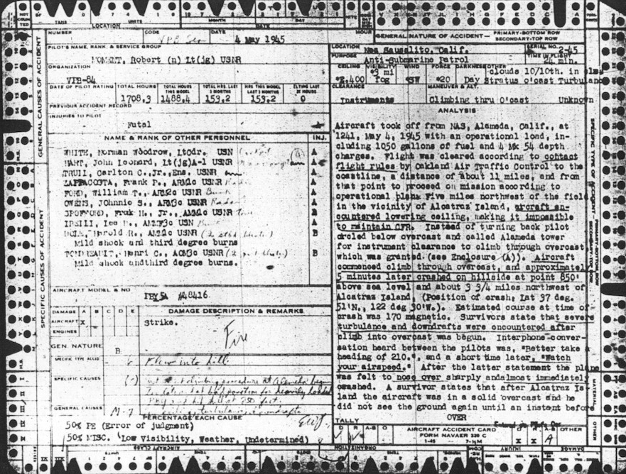
The above crash report is made of two pages. On the first page, there are two sections, left and right, and they give details of the aircraft such as registration number and make, crewmembers names and ranks. Some reports would have more pages, depending on the information available, and there may also be crash pictures of the wreck.
The structure of the first page is: The first few rows on the left column gives the date of the accident, name of the pilot and organisation to which the pilot belongs to. The fourth row gives information about the pilot, such as the date of the pilot rating, total hours flown, total hours flown in the aircraft model that crashed, total hours flown in the last month and the total hours flown in the same model in the last month. The information is useful in determining the skill level of the pilot, and the higher the number of hours flown, means greater the skill. Information about the number of flying hours in the model that underwent the accident goes to prove the skill that the pilot had on the aircraft model. One of the rows also tells the previous accident record for the pilot, and the row ‘injuries on pilot’ refers to the injuries that the pilot sustained, and in the above accident report, the injuries are given as Fatal. The next row is named as ‘Name and rank of other personnel.’ This becomes very important and proof of other members who were on the flight. Insurance agencies rely on this information to establish if a person was abroad on an ill-fated flight. Details such as the name, rank, and nature of the injury are given. The next row gives the aircraft model and number. This refers to the type of aircraft model and the unique registration number. Each aircraft, just like the chassis number of an automobile, is given a unique registration number. Even when ownership changes or the aircraft is transferred to another base, this number will never change, and aircraft can be traced with this number (AAIR. 2007).
Next comes the information about the damage to the aircraft and the engines, on a rating A to E and A means that the damage is total and the aircraft is junk, while E means that the aircraft sustained minor damage. The row under ‘damage description and remarks’ gives brief information about the accident and a declaration that gives the opinion about the accident such as 50% pilot error – error of judgement and 50 low visibility and weather conditions (AAIR. 2007).
The right column gives much more details of the crash and how it happened. The narration may have been obtained by eyewitnesses on the ground or by survivors or by other aircraft that may have been flying in the vicinity. The section gives the location of the accident and the serial number of the crash report. Below it, there is a purpose of the mission and the time in flight in minutes up to which the aircraft was flying. Below it is given the ceiling of the clouds, the amount of visibility and if the fog was present, the wind direction and force, if it was darkness and the type and extent of clouds. Below it gives the manoeuvre and altitude of the aircraft. This means what the pilot was doing when the accident happened, such as climbing, descending or level flight. The lower section gives the analysis, the most important part of the crash report. In this section, a brief history of the flight is given and details of when and where it took or, amount of fuel the plane carried, munitions and arms, exact details of the location with reference to landmarks. The rest of the section would give details of events in the flight that led to the accident. If the pilot decided to ignore the orders and the flight plan, these are mentioned. The section would also give the speed of the aircraft, coordinates of the plane when the accident happened, the direction the pilot was taking, latitude and longitude and other details. Impressions of the survivors are also noted (AAIR, 2007).
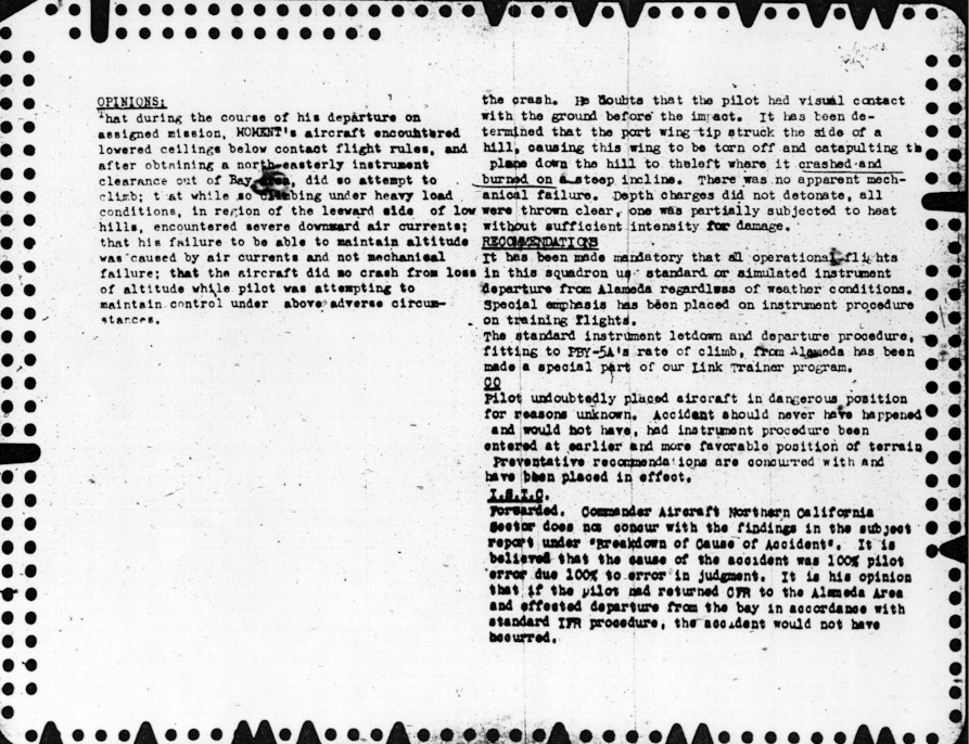
The second page of the report would have detailed opinions from experts on how the accident probably occurred and what the pilot may have been doing to make the aircraft crash. Since there would be only guesswork or the testimony of other pilots or survivors, this section would form an experts view. The page also provides a number of recommendations for another pilot to follow and to ensure that a repeat of the same accident does not occur. Attempt it made to either clear the pilot or state fairly if the accident was caused due to pilot error. The recommendation tells the lessons learned and how pilots can learn from these mistakes. The following image provides a picture of the second page of the crash report (AAIR. 2007).
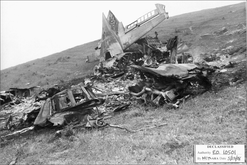
In addition to the above pages, there would be maps of the crash site giving landmarks and coordinates of the wreck along with images of the wreck. An image of the wreck is as below.
Modern-day Crash Reports
Large modern day aircraft often carry hundreds of passengers besides thousands of litres of highly explosive fuel. If one of these large aircraft crashed in a crowded city or a suburb, in addition to the passengers on board, hundreds of citizens living in towns and cities would die. Hence, the safety features of modern aircraft are much more advanced than their counterparts of the World War II vintage. Modern aircraft are always in radio contact with the nearest air traffic control towers. Most of them have advanced instruments control along with GPS guidance systems. In the unfortunate event of an accident, the wreck is immediately found, even if the crash occurred in an open sea or in a remote jungle. With advanced search and rescue crews available, rescue and help to aid any survivors are immediately done. With the implementation of the black box, it is possible to hear the conversation of the crew. The black box records conversations in the cockpit and is designed in such a manner it can resist severe fire, explosion and impact from the crash. Since modern day crashes can be easily traced by Federal agencies, as such there is not much scope for the aviation archaeologist. The following table gives some sample crash reports:
Table 2.1. Sample Crash Reports from 1943 and Concorde
 | 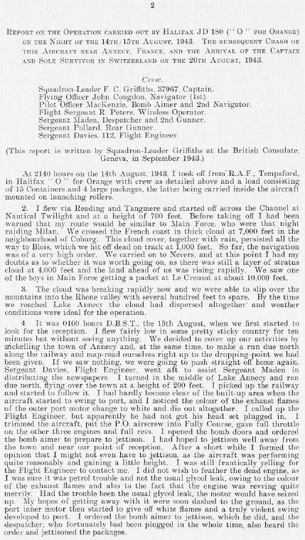 |
| Crash report of Halifax JD 18O (‘O’ for Orange), 15 August 1943, France | |
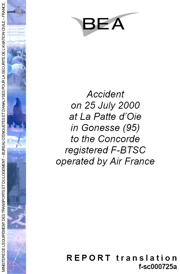 | 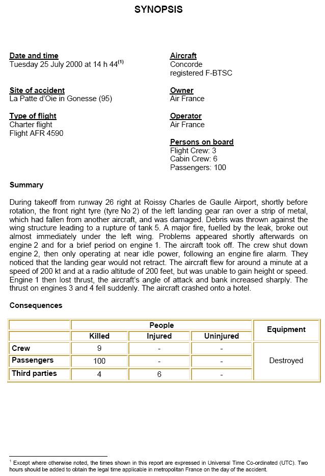 |
| Crash Report of Concorde, 25 July 2000, France | |
World War II Aircrafts
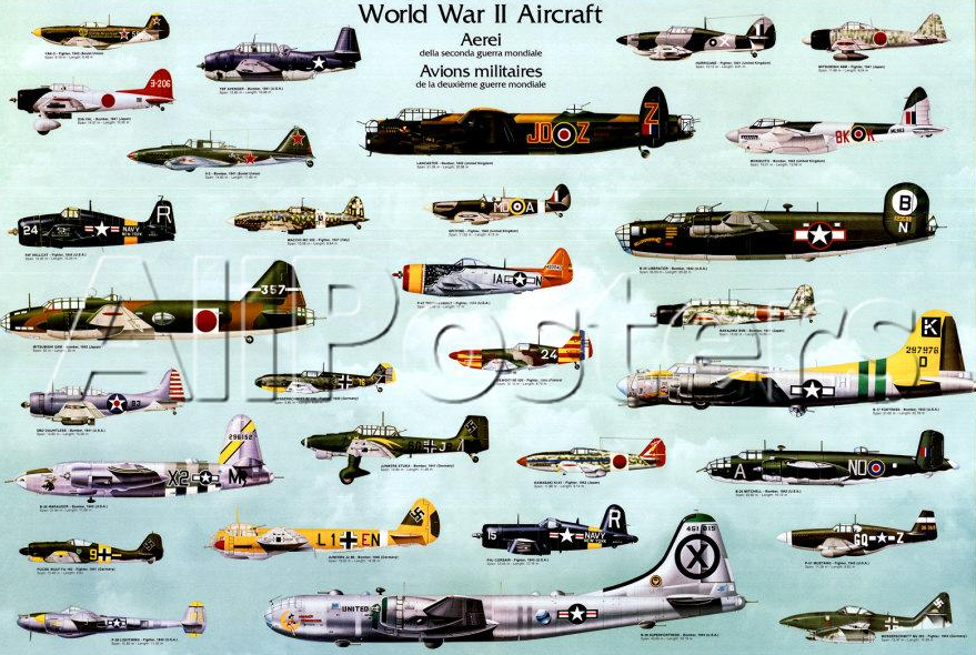
The aviation archaeologist would be primarily attempting to find wrecks of World War II-era. There were a number of aeroplanes that were used during the war, and many of the models continued well into the late 1950s. While becoming an expert in these aircraft would require a very dedicated study, the aviation archaeologist has to be at least aware of different models that were in use during the war, their basic shapes, different military insignias and other such details. While it is true that a wrecked machine would in no way resemble the magnificent warbirds in their original flying glory, the aviation archaeologist has to be aware of how the aircrafts looked.
It is also recommended that books relating to the war and the airmen who flew the aeroplanes should be read so that an understanding of the glory and the hardships that the airmen went through to defend their country would be known, and the various sacrifices they made is better understood. Aviation archaeology is not about voyeurism or for thrill-seekers, but the aviation archaeologist would be examining the remains of human tragedy in the last moment of suffering. To reiterate, aviation archaeology is not a kind of hunt for pirate treasure but a homage and tribute and an effort to be taken with humbleness to locate the remains of the brave souls and bring back the remains to their loved ones.
Summary of Crash Reports
Obtaining an authentic and official crash report is the first step in taking up aviation archaeology work. The crash report gives details such as information about the aircraft model and registration number, names of pilot and crew, an area where the plane crashed, coordinates and landmarks of the crash site, reason for the crash, weather conditions and other details. Crash reports can be obtained from a number of websites, and while some of them are available free, some sites require a small payment to be made. Aviation Archaeologists need to make themselves familiar with different models of aircraft used in World War II and also know about different insignias, aircraft registration numbers and know how to read a map.
Rules and regulations about Aviation Wrecks
Aircraft wrecks and crash sites are not free property, and the ‘finders keepers’ concept is not applicable. Any wrecks that are found in the territorial boundaries of land and sea of a country are usually the Sovereign property of the country. However, many countries give a licence or permit for aviation archaeologists to explore and report any wrecks. This section discusses the legal aspects of aviation archaeology.
Sunken Military Craft act – USA – H.R. 4200
The United States Government has passed the ‘Ronald W. Reagan National Defence Authorization Act for Fiscal Year 200’ that provides for rules and regulations related to sunken aircraft of US origin or foreign origin, found in areas under US jurisdiction (H.R. 4200. 09 December 2004). As per the property clause of the US constitution, the US government is given indefinite ownership of any craft belonging to the US Military that is found within the territorial jurisdiction of the United States of America. The new act removes a lot of uncertainty, and it reduces the inconvenience, cost and litigation from finders. When the law is clear, there is greater certainty that would discourage any challenges to the ownership of the property belonging to the country. Other countries would also be expected to respect the laws and ensure that there is a parallel expression of the foreign country’s sovereign interest. The rules provide for: protection of any US military aircraft, ship or any other vessel, irrespective of the location; protection extension to the graves and any internment for military personnel who are lost and buried; protection of any important artefacts related to history or archaeology; codification of any laws that would support the US ownership of sunken crafts; instituting mechanisms that would permit enforcement of civil laws that would stop unauthorised excavation or disturbance of the wrecks; laws that would not affect any salvage operation of private and merchant wrecks or diving activities that were taken up for recreation.
The statute has a number of sections, and these are explained as under. This is a very important section, and aviation archaeologists have to know the rules and regulations that cover their activities. Any violations of the act can lead to imprisonment under the espionage act and or levy of substantial fines of 100,000 USD or more. The acts are reproduced in full and are very important for this paper:
Section 1401: Preservation of title: “Right, title, and interest of the United States in and to any United States sunken military craft: (1) shall not be extinguished except by an express divestiture of title by the United States; and (2) shall not be extinguished by the passage of time, regardless of when the sunken military craft sank” (HR. 4200. 2004).
SEC. 1402. Prohibitions: “(a) Unauthorised Activities Directed at Sunken Military Craft- No person shall engage in or attempt to engage in any activity directed at a sunken military craft that disturbs, removes, or injures any sunken military craft, except – (1) as authorised by a permit under this title; (2) as authorised by regulations issued under this title; or (3) as otherwise authorised by law. (b) Possession of Sunken Military Craft- No person may possess, disturb, remove, or injure any sunken military craft in violation of – (1) this section; or (2) any prohibition, rule, regulation, ordinance, or permit that applies under any other applicable law. (c) Limitations on Application – (1) Actions by the United States- This section shall not apply to actions taken by, or at the direction of, the United States. (2) Foreign Persons- This section shall not apply to any action by a person who is not a citizen, national, or resident alien of the United States, except in accordance with – (A) generally recognised principles of international law; (B) an agreement between the United States and the foreign country of which the person is a citizen; or (C) in the case of an individual who is a crew member or other individual on a foreign vessel or foreign aircraft, an agreement between the United States and the flag State of the foreign vessel or aircraft that applies to the individual. (3) Loan of Sunken Military Craft- This section does not prohibit the loan of United States sunken military craft in accordance with regulations issued by the Secretary concerned.” (HR. 4200. 2004).
SEC. 1403. Permits: “(a) In General- The Secretary concerned may issue a permit authorising a person to engage in an activity otherwise prohibited by section 1402 with respect to a United States sunken military craft, for archaeological, historical, or educational purposes, in accordance with regulations issued by such Secretary that implement this section. (b) Consistency With Other Laws- The Secretary concerned shall require that any activity carried out under a permit issued by such Secretary under this section must be consistent with all requirements and restrictions that apply under any other provision of Federal law. (c) Consultation- In carrying out this section (including the issuance after the date of the enactment of this act of regulations implementing this section), the Secretary concerned shall consult with the head of each Federal agency having authority under Federal law with respect to activities directed at sunken military craft or the locations of such craft. (d) Applications of Foreign Crafts – At the request of any foreign State, the Secretary of the Navy, in consultation with the Secretary of State, may carry out this section (including regulations promulgated pursuant to this section) with respect to any foreign sunken military craft of that foreign state located in United States waters” (HR. 4200. 2004).
SEC. 1404. Penalties: “(a) In General- Any person who violates this title, or any regulation or permit issued under this title, shall be liable to the United States for a civil penalty under this section. (b) Assessment and Amount- The Secretary concerned may assess a civil penalty under this section, after notice and an opportunity for a hearing, of not more than $100,000 for each violation. (c) Continuing Violations- Each day of a continued violation of this title or a regulation or permit issued under this title shall constitute a separate violation for purposes of this section. (d) In REM Liability – A vessel used to violate this title shall be liable in REM for a penalty under this section for such violation. (e) Other Relief- If the Secretary concerned determines that there is an imminent risk of disturbance of, removal of, or injury to any sunken military craft, or that there has been actual disturbance of, removal of, or injury to a sunken military craft, the Attorney General, upon request of the Secretary concerned, may seek such relief as may be necessary to abate such risk or actual disturbance, removal, or injury and to return or restore the sunken military craft. The district courts of the United States shall have jurisdiction in such a case to order such relief as the public interest, and the equities of the case may require. (f) Limitations – An action to enforce a violation of section 1402 or any regulation or permit issued under this title may not be brought more than eight years after the date on which – (1) all facts material to the right of action are known or should have been known by the Secretary concerned; and (2) the defendant is subject to the jurisdiction of the appropriate district court of the United States or administrative forum” (HR. 4200. 2004).
SEC. 1405. Liability for Damages: “(a) In General- Any person who engages in an activity in violation of section 1402 or any regulation or permit issued under this title that disturbs, removes, or injures any United States sunken military craft shall pay the United States enforcement costs and damages resulting from such disturbance, removal, or injury. (b) Included Damages- Damages referred to in subsection (a) may include – (1) the reasonable costs incurred in storage, restoration, care, maintenance, conservation, and curation of any sunken military craft that is disturbed, removed, or injured in violation of section 1402 or any regulation or permit issued under this title; and (2) the cost of retrieving, from the site where the sunken military craft was disturbed, removed, or injured, any information of an archaeological, historical, or cultural nature” (HR. 4200. 2004).
SEC. 1406. Relationship to other laws: “(a) In General- Except to the extent that an activity is undertaken as a subterfuge for activities prohibited by this title, nothing in this title is intended to affect – (1) any activity that is not directed at a sunken military craft; or (2) the traditional high seas freedoms of navigation, including – (A) the laying of submarine cables and pipelines; (B) operation of vessels; (C) fishing; or (D) other internationally lawful uses of the sea related to such freedoms. (b) International Law- This title and any regulations implementing this title shall be applied in accordance with generally recognised principles of international law and in accordance with the treaties, conventions, and other agreements to which the United States is a party. (c) Law of Finds- The law of finds shall not apply to– (1) any United States sunken military craft, wherever located; or (2) any foreign sunken military craft located in United States waters. (d) Law of Salvage- No salvage rights or awards shall be granted with respect to: (1) any United States sunken military craft without the express permission of the United States; or (2) any foreign sunken military craft located in United States waters without the express permission of the relevant foreign state. (e) Law of Capture or Prize- Nothing in this title is intended to alter the international law of capture or prize with respect to sunken military craft. (f) Limitation of Liability- Nothing in sections 4281 through 4287 and 4289 of the Revised Statutes (46 U.S.C. App. 181 et seq.) or section 3 of the Act of 13 February , 1893 (chapter 105; 27 Stat. 445; 46 U.S.C. App. 192), shall limit the liability of any person under this section. (g) Authorities of the Commandant of the Coast Guard- Nothing in this title is intended to preclude or limit the application of any other law enforcement authorities of the Commandant of the Coast Guard. (h) Prior Delegations, Authorisations, and Related Regulations- Nothing in this title shall invalidate any prior delegation, authorization, or related regulation that is consistent with this title. (i) Criminal Law- Nothing in this title is intended to prevent the United States from pursuing criminal sanctions for the plundering of wrecks, larceny of Government property, or violation of any applicable criminal law ” (H.R. 4200. 2004).
Protection of Military Remains Act 1986 in the UK
All remains of military aircraft, ships and other vessels are protected under the Protection of Military Remains Act 1986. The act has two types of provisions for protection: controlled sites and protected places. As per the act, locations of the wrecks are designated as burial sites and other than the designated authority, no one else is allowed to interfere with the remains. Protected places refer to the crashes that may be named and that can be regarded as protected places even if the exact location of the wreck is not known. So, a crash of a UK military aircraft would be designated as a protected place even when the actual wreck and remains may not have been identified or discovered. This act applied only to those vessels that have sunk after 1914, 14 August. As per the act, it is an offence if unauthorised personnel attempt to interfere, excavate, disturb and remove any items from the site. The rule is ‘look, don’t touch and don’t penetrate’. On the other hand, controlled sites are specifically identified areas by location and identification of the site where the vessel may have crashed or sunk in the last 200 years. Any activity such as exploring, diving in the vicinity, attempting to enter the vessel is strictly banned. When an aviation archaeologist comes across such a site, then he is supposed to inform the Ministry of Defence, who may then take up the required measures to secure the remains (UK, 2007).
According to BAAC (2007), during the 1970s, there was a huge interest in aviation archaeology as many people took up the work for the sake of obtaining souvenirs and for finding spare parts. The UK government initially renounced all claims on the wrecks of the aircraft, and hundreds of wrecks were pilfered by treasure hunters. The government later recanted and created the rules that declared all the wrecks as Crown property.
The Ministry of Defence (MoD, 2007) grants licences to private individuals to carry out research for a specific site only. The licence is granted, subject to a number of rules and regulations. As per the rules of MoD, a licence is needed to undertake excavation and examination for aircraft crashes that belong to the military. If there are any human remains in the wreck, or if there are substantial amounts of live ordnance such as bombs, then a licence is not issued. If the wreck lies in the estate of a private landowner, then written consent from the landowner is required before any permission or licence is given. If the wreck rests in publicly owned property such as parks, wildlife sanctuaries and other areas, then special permission has to be obtained. The MoD may appoint a representative to study the wreck as and when it feels is required. In some cases, local governing bodies and councils would have certain requirements and reassurances that have to be met before the licence is granted, and this is particularly true when the wreck lies in historical sites. Licences are granted on the clear understanding the excavated items have to be surrendered to the MoD without t any compensation. All items belonging to the crew have to be returned to the ministry along with any official logs and records that may be found in the wreck. Some items ownership may be transferred to the licensee if the government feels that they are not of much value. If the licence holder attempts to hide any of the items found in the wrecks, then he is liable for prosecution.
Impact of untrained archaeologists on the Wrecks
BAAC (2007 has reported about the treasure hunters who come in the guise of aviation archaeologists. The report suggests that many of these people are not trained or understand the philosophy behind aviation archaeology. Their only intention was to collect memorabilia related to World War II and then dispose of it off in the black market or to private collectors across the world. According to the report, in the 1970s, hundreds of wrecks were hunted out, and their contents pillaged, without any respect for the dead crew whose remains were probably disturbed. The MoD (MoD, 2007) places a strict prohibition on such activities, and offenders would face legal action if such incidents were reported. In the meantime, the valuable history of the aviation of the Second World War is irrevocably lost, and the remains of the aircraft crew are lost forever. There is a sizeable demand for aircraft components as spare, and these illegal archaeologists attempt to pry apart the wreck in the hope that some serviceable parts may have survived. Components such as the engine, control panels, landing gear elements and others can be salvaged to some extent. It was to prevent such illegal acts that the MoD brought in the Protection of Military Remains Act 1986.
Aviation Archaeologists need to understand that their role is restricted to only carrying out research on a downed aircraft, attempt to find out details of the crew and then report the find to the MoD to obtain a license to undertake more research. They should not attempt to excavate the remains, pry apart the wreck or take up other such activities. After the licence is granted, the licence holder, along with some assistants, can take up a closer examination of the wreck and document the findings. This aspect is very important in aviation archaeology.
Technology and Equipment needed
The previous chapter has explained the importance of crash reports and the rules and laws that govern aviation archaeology. This chapter provides an understanding of the tools and equipment needed for fieldwork.
Preparing physically for field trips
Aviation archaeology is an intense outdoor activity and requires the practitioner to hike through mountains, jungles, deserts, swamps and other very rough terrain, in many cases, far away from human habitation. The practitioner needs to have a good physique and good stamina to sustain long hikes and must be used to living in tents, knowing how to ward off attacks from wild animals, snakes and other creatures. Therefore, basic survival camp training is necessary if one wishes to become an expert. In addition, one has to know about first aid, how to take care of wounds and abrasions and live rough. This is not a pastime for the weak or people with any bodily conditions that would prevent them from climbing cliffs or wading through lakes and swamps. Since one would be walking through wildlife parks or mountains, there are certain etiquettes such as avoiding littering, taking care of campfires to avoid wildfires and other such precautions.
Reading Maps and Learning About Navigation
Aviation archaeologists need to know how to read topographical maps. Topographical maps have to be used since such maps give details of the topography and important landmarks, so it is possible to know the locations of mountains, swamps, forest cover, roads and other natural formations. These maps are available from various geographic survey institutes. Before beginning the expedition, it is important that the natural barriers and topography should be studied. Once the destination area is known, then it is possible to plot a route using GPS devices. However, only relying on a GPS will not help, and the archaeologist should know how to read maps and use the compass (Kjellström, 1994).
The following figure shows a typical topography map of a region. Details of the map are shown in the image. Along with the topography, a number of other details are also given, and they are briefly explained as below:
Some of the terms are:
Sheet Name, Sheet Number, Series Name: These are identified by the numbers 1, 2, 3 and 4 and give details of the sheet that you are referring to. There is nothing like a single map, and a map belongs to a series of maps, and each series would have a number of sheets. The sheet gives the local information, while the series would give the top view information. Therefore, a sheet may refer to the actual site, such as a park or a mountain, while the series would give information about the county, state and other upper levels. Maps are typically drawn to the scale of 1:100,000 or 1:50,000 or 1:25,000, and the units such as kilometres or miles should be known. Therefore, a distance of 1 inch on a map would mean an actual distance of a few hundred miles.
Series Number, Edition Number: These are identified in the figure with numbers 5 and 6. The series number is a sequence of numbers used to identify the maps, while the edition number refers to the version of the map. It is important to have the latest edition of the map as any changes in the topography such as river movements, dams, lakes, roads, or towns would be shown. The date is also given, and this refers to the date when the map was printed. While it is not possible to know if the sheet you are holding is the latest edition, before beginning a field trip, it is essential to confirm and obtain the latest edition.
Boundaries index: This is shown at the margins and gives names of counties, state boundaries and other details that would be touching the area shown on the sheet. The boundary index is important to know so that you would know if the field trip would mean crossing any state boundaries that may have different rules and laws.
Elevation Guide: It gives information about the major landforms and allows the terrain to be identified by different elevation bands, major drainage elements and spot elevations. So the reader would know how high or low a particular terrain is.
Declination Diagram: It gives the angular relation of grid north, true north, the magnetic north and other features.
Bar Scales: These allow distance to be converted from the map to actual distance on the ground. There may be three-bar scales, and precaution should be taken to use the correct scale and units while measuring the distance.
Notes: There are different notes such as Contour Interval Note, Spheroid Note, Grid Note and Projection Note. Contour note gives the vertical distance that occurs between contours lines; spheroid note is used to identify the XYZ axis of the globe; grid note provides data that relates to the grid system employed and the distance in between adjacent grids. Projection does not give the framework used in the creation of maps.
Colours utilised in maps: A number of colours are used in maps to identify the topography of individual areas. It is important that a user should know what a certain colour in the map would mean. Black is used to identifying human-made structures such as roads, spot elevations that are surveyed, buildings and other objects. Red Brown is used to indicating the relief structures, while blue is used to indicate water bodies such as rivers, swamps, lakes, drainage or canals. Green is used to indicate vegetation such as woods, farms, or forests, while red is used to identify towns, cities and other locations where humans exist.
Learning how to Navigate
Maps only tell you where a wreck is located, and the task of physically going there depends on navigation methods and skills. There are different methods, and the most basic is using the compass. Modern navigation methods such as GPS are also available, but it is essential to know how to navigate using a Compass.
Using a Compass
There are different types of compass, such as the wrist or pocket type, that has a small magnetic arrow with dials, and the arrow would always point north. The Lensatic Compass is more precise and simple, and it can be used along with a protractor to find a location. The following figure shows an illustration of a Lensatic compass.
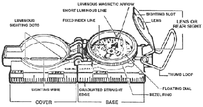
The compass has a pivot mounted floating dial that rotates, and it has a face with luminous figures and arrows. Also, a magnetic arrow would always point in the direction of the magnetic north. The body has two scaled, inner and outer. The inner scale with red colour signifies degrees, and the outer scale gives the mils. The dial is covered with a glass, and there is a fixed black index line. The bezel rings are provided with a ratchet that, when turned, produced a click. When the ring is rotated fully, it clicks 120 times, and each click is about 3 degrees. In addition, a short luminous line is used along with the arrow and is enclosed in the glass. A lens is provided and is used to read the readings on the dial, and it has a rear sight slot that is used for sighting objects along with the front. The rear sight should be opened by 45 degrees so that the dial floats freely. The scale for the compass is 1:25,000 or 1:50,000. There are different techniques in using the compass, and some of them are the centerhold technique, Compass-to-Cheek method, Preset the Compass and follow the azimuth, bypassing methods to circumvent obstacles and other methods. An illustration of the methods is as given below (Burns, 2004):
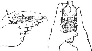 Figure 3.3. Centerhold Method for Compass | 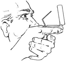 Figure 3.4. Compass-to-cheek Method |
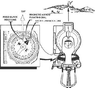 Figure 3.5. Preset Compass to Follow an Azimuth | 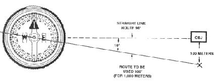 Figure 3.6. Offset method for objective |
The compass can be used to measure the azimuth, for measurement of the sighted object, to preset the compass and follow an azimuth, to bypass natural obstructions such as mountains, rivers, forests or lakes. It is very important to note that when using the compass, the user should not be carrying any iron-based items. It is better to leave the rucksack on the ground, move away from other members of the team and then take a reading. Since the compass has a magnetic arrow, the presence of iron or while standing near an automobile and taking readings can give errors (Burns, 2004).
Using Field Expedient Techniques
Certain techniques are available that can be used when the compass is broken or lost and the GPS system is not available. These are called expedient field techniques. Some of them are the shadow tip method, start method and watch method. These techniques are for survival and should not be relied on as the primary navigation aid (Seidman, 2000).
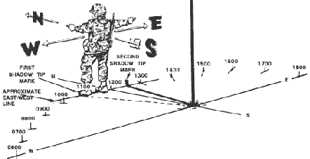
Shadow Tip Method: In this method, the direction can be found by using the sun, and an illustration of the method is shown below. A long pole or stick is to be placed in the ground, firmly and the tip of the stick should be marked with a stone. The direction of the first shadow mark would always be in the western direction. After waiting for a few minutes to allow the shadow to move, mark the new position and draw a line that passes through the two marks, and this is the east-west line. If a person stands such that the first mark is to the left, then the right side would be east, the south would be behind, and the north is in the front.
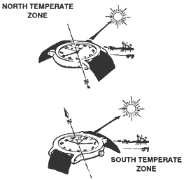
Watch Method: A watch can be employed for finding the true north or true south. The hour hand has to be pointed to the sun in the North Temperate Zone, and then a south line would occur in the middle between 1200 hours and the hour hand. In the South Temperate Zone, the 1200 hour dial is made to point at the sun and midway between 1200 hours and the hour line in the north line. However, this is a very crude method and would be used when no other navigation method is available.
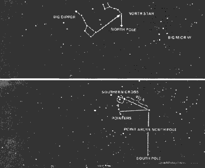
Navigation by Stars: This method has been used since ancient times, and ancient seafarers managed to travel thousands of kilometres across the sea by navigating with the stars. The North Star is about 1 degree off true north and would not appear to change its place since the Earth’s axis is pointed at it. However, the North star is seen only in the Northern hemisphere, and azimuth can be verified using this star. In the Southern hemisphere, the Southern Cross can be used. An illustration of the sky and method of finding the direction using the North Star and the Southern Cross is shown below.
Navigating with GPS
Global Positioning System – GPS is a radio navigation system developed by the US Department of Defence. The system allows users to find their position on land, air and sea in three-dimension coordinates anywhere in the world. It would be possible for people in remote areas to know where they are on the Earth. Almost the whole world is covered by satellites. While GIS is used by experts with extensive equipment, software and hardware, GPS devices are available as small handheld devices that can be used by an ordinary trooper who would not be expected to know intricate details of complex raster imaging algorithms. Often GPS and GIS are integrated. While GPS would tell a person of his location, GIS would tell him about the topography of the region (PM GPS, 2008).
The DOD provides access to agencies and equipment manufacturers who can then create GPS systems. There are three components: User, Control and space. Space refers to 24 satellites that are placed in geostationary orbit around the Earth so that at any point, six would be available and relay information to any user in the world. The control segment is made of the Colorado Springs master control station supported by five monitor stations along with antennas that track the GPS satellites and receive information from them. There is a constant relay of information, and it is possible to precisely know the coordinates of each satellite. The user segment, including the army, is made up of processors, receivers and antennas. These devices allow the troops to receive information precisely about the location anywhere on the Earth, estimate their speed and take the satellites as the reference point (Garmin, 2008).
GIS Systems
Geographic Information System – GIS is used to create, manage and analyse geographic and topographical features of a particular landscape so that the information can be used as and when needed. The term is used to denote hardware and software applications that would store, analyse, edit and integrate the geographic features of an area. Geographic features refer to rivers, mountains, plains and other features of an area, be it a small village, a state and even a country (DTIC, 2007).
The army has access to certain methods of gathering data that is not available to private agencies. These include the use of government-owned satellites that create high-resolution Cartesian images of a region. In techniques with digitised data creation, hard copies of survey maps are fed into a computer-aided design software application. It creates raster images of continuous data such as rivers, mountains and also discontinuous forms such as houses, buildings, roads and so on. Some techniques used include creating a trace of the geographic data on an aerial image to trace a digitising tablet. The image that is formed is typically a raster image or a scalable vector image. The images that are formed are indexed as per keywords and tags and stored in large relational databases so that the information can be used as and when needed (DTIC, 2007).
Important Gear to have
An aviation archaeologist needs to have a few essential items that would help him during field hikes. Some of them are (Seidman, 2000):
Pedometer: These lightweight devices measure the actual distance travelled while walking and hiking. The device is important when knowing the speed at which the hike is made, the distance covered, the distance that remains and so on. Devices are also available with backlit illumination for viewing during night hikes.
Headlamps: These devices can be strapped to the head and leaves the hands free while walking. Devices are available with features such as tilting head, adjustable strap, multiple bulbs with flood focus and different levels of lighting. Lighting with low illumination is available for up to 120 hours, and devices with rechargeable cells are available.
Compass: This is a very important tool to have, and different varieties with wrist mounting, handheld devices and others are also available.
Metal Detectors: These devices become very important when searching for metals that are buried under the soil. During a crash, pieces of metal can be scattered over a large distance, and some may be buried under soil or debris. It is not possible to excavate a large area of land, and a metal detector comes in handy. Portable handheld devices that weigh very little are available, and these can be carried in the rucksack. Since plastic was not in common use during World War II and metal was commonly used, a good metal detector is very useful in finding out pieces of the aircraft, ordnance and personal items of the crew.
Tool Kit: Ideally, a tool kit should be carried along though this may weigh a lot. Items such as a small pickaxe, spade, axe, knives, Swiss army knife and other items are needed. These tools can be used to clear the ground for a campsite, take up minor excavations and so on.
Camera: A good resolution, digital or film camera with a zoom facility is required to record the field trip and to take pictures of the wreck. Pictures offer proof that you have actually visited the site.
Two Way Radios: These are optional devices but useful for team members to keep in touch with each other. They have a range of about 5 kilometres and are available with rechargeable cells. The devices can be used in all types of weather and are impervious to rain and snow.
GPS Systems: This is a very valuable navigation aid, and before starting on the hike, the coordinates and the map to be followed can be programmed. There are many commercially low-cost devices available, and since the cost would depend on the accuracy of the positioning, low-cost devices that provide an accuracy of about 50 to 100 meters can be used. Devices used in the military for precision bombing are accurate to a couple of meters, and such accuracy is not required for aviation archaeologists. GPS handphones are also available, and these would allow conversations in any part of the world, but they are expensive.
Good Shoes: These items are perhaps the most important that an aviation archaeologist can have. A person walks in his shoes, and uncomfortable footwear that causes sores and chafing are to be avoided. It is better to ‘break’ new shoes by wearing them for a few days before going on a field trip.
First Aid Kit: It is a good idea to have a first aid kit and, more importantly, know how to use it and treat yourself and others when any injuries occur. It is also recommended that the student should take a first aid course before venturing into the field.
Warm Clothing: Even in summers, nights can be very cold, and a jacket or other such apparel, preferably waterproof, is recommended.
Conclusions
Aviation Archaeology is the practice of searching and recovering sites and wreckages of cashed aircraft. The subject is also known as aircraft archaeology, wreckology, and aerospace archaeology, crash hunting and other names. The activities involved include carrying out research using crash reports, finding and documenting the crash, recovering items from wreckages, preserving the artefacts and publishing reports about the crash. The impact of untrained and illegal aviation archaeologists has been very severe since these people are treasure hunters and interested only in the artefacts and memorabilia that they can purloin. These people have destroyed many aircraft wrecks and also disturbed the final resting place of many brave airmen.
Crash reports provide a lot of information such as details of the aircraft and crew, last reported location and position and the area over which the aircraft was lost. Crash reports form the first body of knowledge that the aviation archaeologist has to use to begin the work. Governments of the UK and US have instituted acts and rules that forbid non authorised people attempting to excavate the remains of aircraft wrecks. Archaeologists need to obtain special permission before they are granted a licence to excavate the remains.
The paper has examined in detail how to read maps that are available, and various features of the map have been examined. Navigation techniques using a compass, field-expedient techniques, navigation with GPS and GIS systems have been discussed. The paper would serve as a starting point for aviation archaeologists.
References
AAIR. 2007. Aircraft Crash Reports. 2008. Web.
All Posters. 2007. World War II Aircraft. Web.
BAAC. 2007. Military remains act: British Aviation Archaeological Council. Web.
BEA. 2000. Concorde Crash Report: Bureau d’Enquêtes et d’Analyses pour la Sécurité de l’Aviation Civile – English Translation. Web.
Brotherton Elizabeth. 2005. Four questions – Aviation archaeology Series: av.plane. 0721. Orange County Register. Santa Ana, Calif. p. 1..
Burns Bob. 2004. Wilderness Navigation: Finding Your Way Using Map, Compass, Altimeter & Gps (Mountaineers Outdoor Basics). Mountaineers Books.
Cox Doug. 2005. USAPhotoMaps: JDMCox, Free Windows Software. Web.
DTIC, 2007. An Overview of the Army GIS (Geographic Information Systems) Research Program. Web.
Garmin, 2008. GPS Guide for Beginners. Web.
H.R. 4200. 2004. Sunken Military Craft. 2008. Web.
Kjellström Björn. 1994. Be Expert with Map and Compass: The Complete Orienteering Handbook. Wiley; Revised edition.
Les Daly. 1986. Archaeology with a heart in Holland’s drained inland sea. Smithsonian. 106(8). pp: 1-7.
MoD. 2007. Licence Application Procedure: Ministry of Defence. Web.
Platt Edward. 2000. The explosively booming business of aviation archaeology. London, UK: The Independent. pp: 21-23.
PM GPS, 2008. U.S. Army GPS: GPS user equipment. Web.
Seidman David. 2000. The Essential Wilderness Navigator: How to Find Your Way in the Great Outdoors, Second Edition. International Marine/Ragged Mountain Press.
UK. 2007. Protection of Military Remains Act 1986. Web.